Wednesday, November 20, 2013

Happy #GISDay from Kenya


Team - 

Today is GIS Day around the world and it has been a very busy year. I am here at ICCM 2013 and learning a lot about what everyone is doing in the CrisisMapping community. 

Most recently the Philippine typhoon and MidWest tornadoes have GIS specialists across the globe working in conjunct with the CrisisMapping community to support response agencies. 

Here are some examples of maps being produced for the Philippines response: 


I'd like to recognize the great work of the GISCorps and MapAction this year and look forward to the building bridge we have built between the SAR and GIS professional community.

Monday, November 11, 2013

Tropical Storm #Haiyan / #YolandaPH map resources


View Larger Map of tweets validated through the MicroMapper platform and mapped by GISCorps. For more maps and apps click through the gallery below. 

As Tropical Storm Haiyan / Yolanda makes it way into mainland Asia, the relief efforts are fully underway in the Philippines. I wanted to take a moment here and point out some maps and resources that may be of interest to the Search and Rescue community. 
The CrisisMapping community is serving the United Nations OCHA and UNDAC Teams with up to date information from a wide variety of sources to provide situational awareness and up to date base data for their maps. Check out these sites and the maps below for more information. We will learn a lot from this event and please keep the Search and Rescue and other teams in mind as they are currently engaged in life saving operations.


Here is a partial list of data sources: 


·        Schools and Hospitals (OSM)
·        Maximum Storm Surge (NOAH)
·        Admin Boundaries
·        Cloud cover (NASA, Nov. 9th)
·        Weather Stations (NOAA)
·        Recent earthquake (USGS)
·        OpenStreetMap

Tuesday, October 22, 2013

Search and Rescue GIS Resources for Canada


After our recent MapSAR Training event at SARScene Canada 2013, Rick Laing of Ridge Meadows SAR, Elaine Girrior of Yellowknife SAR, and Peter Devanney of SAR Global 1 agreed to put together a shortlist of resources to start discussion and establish SARGIS collaboration across Canada. Here is what we have put together (this information may be useful even if your response area is outside of Canada).


Basemaps

With regards to basemaps there are many resources available to you already while connected to the internet. For instance, below is a map of all of the Community Maps Program participants who adding even more detail to the World Topographic basemaps. Also within ArcGIS Online and ArcGIS Desktop you have access to the basemap produced by the Open Street Map program. 


View Larger Map

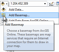
To open these in ArcMap simply use the add basemaps function...

Here is a snapshot of some highly detailed data for Coquitlam 


Base Data

There is a whole section about how to organize your Minimum Essential Data in the Using GIS for Wildland Search and Rescue textbook (free download) and also in an earlier blog post "Pre-planning is half the battle". Base data can be tricky for new GIS users because these datasets tend be rather scattered across the internet and are hard to track down if you do not already work with a GIS Specialist. But we thought we would point out some Canada-specific data sources for all of you here.  

In many cases this will require you to download the data in various formats, unzip the data, add it to your map, and style it appropriately. 

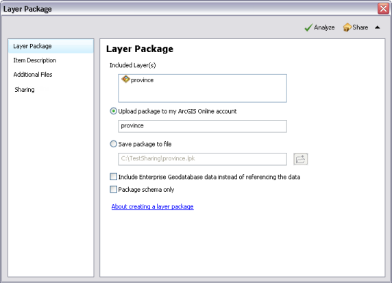
Creating a layer package clipped for your specific area is a great way to keep these data portable and organized. When you unpack them they keep your geography and symbology and can be stored locally, on a portable drive, and ArcGIS Online.


ArcGIS Desktop for Nonprofit Organization Program by Esri Canada. Go to the website and Request Application for Membership

  • $100 for ArcGIS Desktop (administrative fee)
  • Designed for small ground SAR organizations in Canada 
  • Organization can not be a Nationwide and/or Government owned agency
  • Community Based Non Profit Volunteer Organization (with or without a CRA#)
  • Must be associated with SARVAC, CASARA, or Northwest Territories
  • CRA Charity registration number - not needed, simply note your relationship with SARVAC


Download MapSAR template for ArcGIS Desktop from www.mapsar.net

MapSAR is a free tool that runs with ArcGIS 10, 10.1, and 10.2 to store geospatial information, enabling SAR maps to be generated, stored, and printed quickly so that search teams can get out the door faster to look for the missing person.


Join our Discussion Group!

A group for National Park Rangers, Sheriffs, Mountain Rescue Associations and other emergency service people to discuss and help others use and implement GIS (Geographic Information Systems) technology in SAR (Search and Rescue), emergency and day to day operations. Central to our group’s goals is to make GIS techniques and technologies more accessible to non-specialists. Towards this end, we have continued to explore techniques and technologies that can create a more streamlined workflow and effective situational awareness when using GIS. 

What's next?

From here we hope the real discussions can begin. 

  • Should there be a Canada SARGIS User Group? 
  • Where will the next MapSAR Training be? 
  • How can base data and even pre-planned operational data be stored and shared for teams to utilize (see example)?
  • How do I meet local GIS Specialists and work with agencies already using GIS in my area? 

In the meantime, please do visit the NAPSG MapSAR and IGT4SAR for online training videos and stay informed via the SARGIS Discussion Group. Don just uploaded a video that highlights the importance of minimum essential datasets and breaks down some GIS basics here in this video: http://www.youtube.com/watch?v=qdOM9RsQ1ZI

Let's continue the discussion and collaborate around this topic. 

Saturday, October 19, 2013

#MapSAR in Canada - Resources and Updates from @SARSceneCanada

From SAR Scene 2013, Chilliwack, British Columbia - For those of you interested in using GIS for Search and Rescue in Canada, we have some resources for you. 


1) Find out about the ArcGIS Desktop for Nonprofit Organization Program by Esri Canada. Go to the website and Request Application for Membership

  • $100 for ArcGIS Desktop (administrative fee)
  • Designed for small ground SAR organizations in Canada 
  • Organization can not be a Nationwide and/or Government owned agency
  • Community Based Non Profit Volunteer Organization (with or without a CRA#)
  • Must be associated with SARVAC
  • CRA Charity registration number - not needed, simply note your relationship with SARVAC

2) Download MapSAR template for ArcGIS Desktop from www.mapsar.net


3) Join our Discussion Group!


Also while at SARScene a few exciting things are happening. Rick Laing and myself just taught a MapSAR Workshop and tomorrow I will give a presentation on Using GIS in SAR and Rick will be on a SAR Technology discussion panel.

There are already talks of a MapSAR training event next year in British Columbia, location TBD (and perhaps Banff as well). 

Right now - we are integrating MapSAR with ArcGIS Online via the ArcGIS Collector and Operations Dashboard. Below is a view of the action from our web map. Stay tuned for more (including a post within the next week about how to obtain base data for building your minimum essential datasets). Please comment here or on the discussion group if you know of some great place to acquire Canadian base data (trails, roads, hydro, topo etc.) or datasets that you desperately need for your area.

Tuesday, October 15, 2013

A Remedy for Your Basemap Blues

Problem: Slow Maps

So you are on a search and rescue mission using ArcGIS Desktop and while panning and zooming around the map, you are continuously waiting for basemaps to "re-draw". You can't guarantee an internet connection so you want to utilize your local data.


 Solution: Basemap Layers

Some nerdy GIS talk from the help documentation: "Basemap layers are a kind of map layer that provides a framework onto which you display your dynamic operational information. Basemap display performance is very fast. Since basemap layers are relatively static and do not change frequently, their display can be computed once and reused many times. The first time you visit an area at a particular map scale, basemap layer display is computed. The display is recalled on return visits to that area and map scale."

It is FAST! So let's get started.


Step one - Cartography

So this step will vary based on what you use as basemaps for your area. A long time ago Liz Sarow from Esri showed me how to make a nice hill-shaded topo from publicly available data. For California here are some resources:

1) Topos available as Digital Raster Graphics
2) 30m Digital Elevation Models available as Images (or these can be made with any DEM using the Hillshade tool)

The next trick is to add these to your map and style appropriately. I personally use a hillshade-on-topo "sandwich" - but I set hillshade properties as transparency of ~55% and Resample to bilinear interpolation.


Map sandwich!


Step two - Add a New Basemap Layer

Right-click the data frame name in the table of contents and click New Basemap Layer.

Adding a new basemap layerThe new basemap layer in the table of contents

Step three - Select the Layers 

Select the layers that will comprise your basemap and drag them into the basemap layer.Now you have a topo map that also highlights the terrain in your area - more importantly we can now pan and zoom around the map without waiting for redraw.


Please see the help document for more information. You can download my example as a tile package here and the try the steps above.


Other recommendations

  • Create these and store them for your areas of operational responsibility so they are ready to go ahead of time. These can be stored locally and remotely using Dropbox or ArcGIS Online.
  • Do not add any vector layers to your map that you plan on tracing for editing or clicking for attributes - this removes data access. No big deal if you do, just remember to pull the layers back out of the Basemap layer when you need them.
  • Whenever possible - use ArcGIS Online basemaps, they render quickly and feature more often updated content than your old topo and trail maps. See the World Topo Community Basemap and Open Streetmap 
  • RTFM Read the Free Manual: there are lots of other tips & tricks you can use in the ArcGIS Help documentation. Also - join our discussion group and ask the SARGIS geeks yourself! 


Monday, September 30, 2013

#MapSAR now available for ArcGIS 10.2


Jon Pedder from Sierra Madre SAR just released a version of MapSAR that will work on ArcGIS Desktop 10.2. MapSAR for 10.2 will be posted to www.mapsar.net ASAP but it is also available for download from ArcGIS Online from the WiSAR Applications Group. 


For those of you interested in contributing to the MapSAR Project by testing the template or developing tools, please see the MapSAR GitHub repository. 

The goal of MapSAR is to help: 

  • Create and edit field task assignments
  • Monitor progress of assignments
  • Support logistics/communications
  • Document clues, team location and status
  • Incorporate GPS data
  • Store all incident data into a single repository
  • Create and print maps

If you are unsure if you have access to ArcGIS Software and work on a volunteer SAR Team please see the Esri Non-Profit Organization Program. If you feel you may not qualify for this program please send an email to help@mapsar.net. Free training videos are also available on the NAPSG YouTube channel.

Great work Jon and Team for getting this version out!

Also - I have added a download page for a set of ArcGIS Explorer Desktop tools here: Search and Rescue Tools for ArcGIS Explorer Desktop. Please see this page for more details.


***Update - I just updated the item page for downloading MapSAR 10.2, apparently some tools did not zip up. Also, this version can be used for 10.1 as well. 

Saturday, September 14, 2013

#MapSAR Training modules kicking off right now

Jon Pedder and Art Fortini are here at the Sierra Madre SAR Cache in California launching the MapSAR training modules via webinar: Training Announcement 

Thank you NAPSG for all of your support!


NAPSG will make the training videos available (www.youtube.com/user/napsggis)
and I will announce the location here. For those of you assisting with the flood response in
Colorado - please be safe and let us know if you need our help.

UPDATE: If you missed the event or want a recap - the slides and video are posted here: