The NAPSG Foundation Search & Rescue (SAR) Working Group is pleased to announce our 9th Annual SAR and GIS Workshop! Join us for this annual opportunity that brings together professionals from diverse backgrounds, "so that others may live..."
What is SAR? Search and Rescue with a focus on missing person search and wildland rescue.
What is GIS? Geographic Information Systems - "data you can see on map".
What is GIS? Geographic Information Systems - "data you can see on map".
Target Audience:
The primary audience will be SAR Personnel and GIS Specialists who are interested in Public Safety. We especially encourage National Park Service, FEMA USAR, and Mountain Rescue Association Team members to participate!
Workshop Agenda:
Day 1 - Geospatial Concept of Operations for Search & Rescue
- Presentations
- Panel Discussion
- Lightning Talks
Day 2 - Geospatial Decision Support Tools (Basic & Intermediate tracks)
- Paper Maps
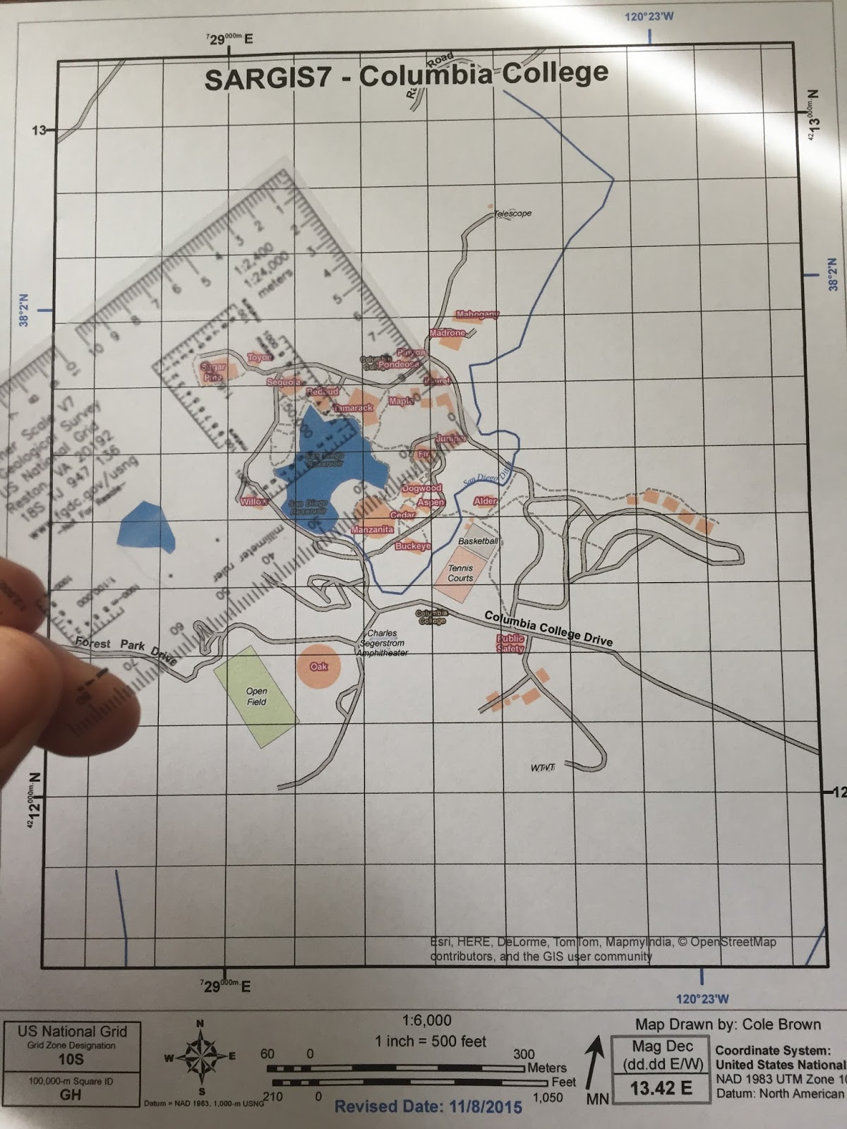
- US National Grid
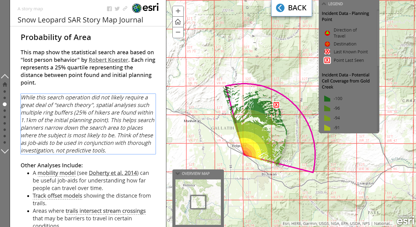
- Spatial Analyses
- Field Apps
- Web Maps and Apps
Basic Track: Participants will learn how GIS can be applied to SAR and will practice using already built geospatial decision support tools.
Intermediate Track: Participants will be introduced to SAR concepts, and they will incorporate existing GIS knowledge to create geospatial decision support tools.
Day 3 - More Training & Testing
Participants will complete the training tutorials and practice using geospatial tools for an instructor “Stress Test”. Also, participants will have the chance to self-assess their capabilities and readiness.
Pre-requisites:
- Basic Training participants (SAR Practitioners) must complete the following short and self-paced tutorial before SARGIS9: Get Started with ArcGIS Online (AGOL)
- Intermediate Training participants (GIS Practitioners) participants must complete the following short and self-paced tutorials, or have equivalent knowledge before SARGIS9: Get Started with ArcGIS Pro and Get Started with ArcGIS Online
Approval Process for Participants:
While this is a no-cost event, a total of 60 registrants will be selected. and would like to have approximately 50% SAR Practitioners (Basic Training) and 50% GIS Practitioners (Intermediate Training) who can commit to completing the pre-requisite training.
Organisations Involved
Day 1 - Geospatial Concept of Operations for Search & Rescue
- Presentations
- Panel Discussion
- Lightning Talks
Day 2 - Geospatial Decision Support Tools (Basic & Intermediate tracks)
- Paper Maps
- US National Grid
- Spatial Analyses
- Field Apps
- Web Maps and Apps
Basic Track: Participants will learn how GIS can be applied to SAR and will practice using already built geospatial decision support tools.
Intermediate Track: Participants will be introduced to SAR concepts, and they will incorporate existing GIS knowledge to create geospatial decision support tools.
Day 3 - More Training & Testing
Participants will complete the training tutorials and practice using geospatial tools for an instructor “Stress Test”. Also, participants will have the chance to self-assess their capabilities and readiness.
Pre-requisites:
- Basic Training participants (SAR Practitioners) must complete the following short and self-paced tutorial before SARGIS9: Get Started with ArcGIS Online (AGOL)
- Intermediate Training participants (GIS Practitioners) participants must complete the following short and self-paced tutorials, or have equivalent knowledge before SARGIS9: Get Started with ArcGIS Pro and Get Started with ArcGIS Online
Approval Process for Participants:
While this is a no-cost event, a total of 60 registrants will be selected. and would like to have approximately 50% SAR Practitioners (Basic Training) and 50% GIS Practitioners (Intermediate Training) who can commit to completing the pre-requisite training.
- National Alliance for Public Safety GIS Foundation
- Mountain Rescue Association
- National Park Service