Showing posts with label Maps. Show all posts

Monday, November 11, 2013

Tropical Storm #Haiyan / #YolandaPH map resources


View Larger Map of tweets validated through the MicroMapper platform and mapped by GISCorps. For more maps and apps click through the gallery below. 

As Tropical Storm Haiyan / Yolanda makes it way into mainland Asia, the relief efforts are fully underway in the Philippines. I wanted to take a moment here and point out some maps and resources that may be of interest to the Search and Rescue community. 
The CrisisMapping community is serving the United Nations OCHA and UNDAC Teams with up to date information from a wide variety of sources to provide situational awareness and up to date base data for their maps. Check out these sites and the maps below for more information. We will learn a lot from this event and please keep the Search and Rescue and other teams in mind as they are currently engaged in life saving operations.


Here is a partial list of data sources: 


·        Schools and Hospitals (OSM)
·        Maximum Storm Surge (NOAH)
·        Admin Boundaries
·        Cloud cover (NASA, Nov. 9th)
·        Weather Stations (NOAA)
·        Recent earthquake (USGS)
·        OpenStreetMap

Monday, September 2, 2013

#MapSAR in Australia Update from #AFAC2013 and #Ozri2013

From AFAC2013 - This has been a great trip to Australia and we are not done yet. I just wanted to give an update on the agencies interested in MapSAR and IGT4SAR and the new friends that will be joining the SARGIS Discussion Group.
On Friday I will be at Ozri 2013 and next week meeting with the Queensland Police about MapSAR and training opportunities for SARGIS. I would like to thank everyone for their hospitality and please welcome our newest discussion group members.

See my Story Map for an interactive tour.

Wednesday, July 17, 2013

#MountainFire map and WildlandFire.com

For those of you interested in following the Mountain Fire in Southern California, I have embedded a live interactive ArcGIS Online map here in this blog.


View larger and more interactive map

The map shows the latest confirmed wildfire perimeter and MODIS hotspots indicating new wildfire activity (with a ~1km horizontal accuracy). For information about this map and the data feeds go to the information page

This version of the map is curated by the FireWhat Team and the incident can be followed via the WildlandFire.com forum thread. Also it looks like the USFS will be actively updating InciWeb with incident details. We look forward to seeing the collaboration between FireWhat and MapSAR teams in the future.

Thursday, July 4, 2013

Expert versus Machine: A Comparison of Two Suitability Models for Emergency Helicopter Landing Areas in Yosemite National Park

Ever wondered if you could use GIS to have a better understanding of where you can land a helicopter for your area? Well, I hope this sheds some light on two possible options. This was the first WiSAR project from my Phd Research


Here is an interactive web map of Yosemite National Park with the output from the maximum entropy algorithm. Green areas are more likely to be suitable landing areas. Blue dots are landing zones used in the past.

Basically in this study we compare two methods for creating a helicopter landing suitability map (see above). We tested the landing suitability map using actual landing areas used by Yosemite helitack during operations. The idea was to test two GIScience methods, but also to give dispatchers and operations an extra location-based tool they can use to decide if it is worth scouting for a landing zone or gearing up for alternatives (litter carry out, short-haul, heli-rappel, etc.) 

Abstract
"Landing a rescue helicopter in a wilderness environment, such as Yosemite National Park, requires suitable areas that are flat, devoid of tree canopy, and not within close proximity to other hazards. The objective of this study was to identify helicopter landing areas that are most likely to exist based on available geographic data using two GIScience methods. The first approach produced an expert model that was derived from predefined feature constraints based on existing knowledge of helicopter landing area requirements (weighted overlay algorithm). 


Yosemite Search and Rescue loading a patient into Helicopter 551 - NPS
The second model is derived using a machine learning technique (maximum entropy algorithm, Maxent) that derives feature constraints from existing presence-only points; that is, geographic one-class data. Both models yielded similar output and successfully classified test coordinates, but Maxent was more efficient and required no user-defined weighting that is typically subject to human bias or disagreement. The pros and cons of each approach are discussed and the comparison reveals important considerations for a variety of future land suitability studies, including ecological niche modeling. The conclusion is that the two approaches complement each other. Overall, we produced an effective geographic information system product to support the identification of suitable landing areas in emergent rescue situations. To our knowledge, this is the first GIScience study focused on estimating the location of landing zones for a search-and-rescue application." Doherty et al. 2013. Professional Geographer 65:3

Next steps are to:
1) Test these methods in other mountainous environments 
2) Upload the python scripts for the generating raster from vector for formatting into Maxent
3) Upload the ArcGIS ModelBuilder model as a python geoprocessing script to GitHub
4) Integrate the model as a tool in MapSAR, ArcGIS Desktop template.

I would love to collaborate on this project and help answer any questions you might have. 

Special thanks to my co-authors Dr. Guo and Otto Alvarez, Yosemite Search and Rescue, UC Merced, the National Science Foundation, and Liz Sarow from Esri for the inspiration. 


Saturday, December 29, 2012

"What is a Field Map?"

So you are on an active Search Operation and someone asks for an assignment map. What do you do? Well hopefully you have already read and digested the Using GIS in Wildland Search and Rescue text and are using the MapSAR templates. Here, Don Ferguson and I dig a little deeper into the topic of what to put on an assignment map.

Image

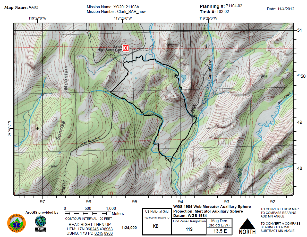
The Task Assignment, or Field Map is an essential element for search teams going into the field in response to search and rescue operations.  These maps provide assistance with team navigation as well as the ability to communicate certain attributes about specific location (e.g. the position of a clue).

Although these maps play a critical role in team safety and search effectiveness, there doesn't appear to be a documented effort at standardizing the basic layout and the information contained in the map. ASTM standards F 1846 and F 2099 have provided guidelines for map symbology and the use of UTM grids, respectively, but these standards stop short of suggested critical information that should be presented on the map itself. In addition, with the adoption of US National Grid as a standard for all Public Safety agencies in the United States you will need to make some modifications to your old UTM/lat long habits soon. For a dynamic USNG overlay you can use web services found on ArcGIS Online or check out the ArcGIS Desktop Help documentation: Adding an MGRS and U.S. National Grid.

What about basemaps? What should we use? The USGS 1:24,000 topographical map has long been the de facto standard map used by wilderness SAR teams in the United States as these maps have provided basic information on geographic features to assist with navigation. These can also be found on ArcGIS Online or downloaded from most State GIS Portals for free. Given the familiarity of SAR personnel with the format of the USGS topo map, teams often settle on a layout similar to that of the USGS maps with information limited to this basemap.  While this may have been adequate for keeping teams safe in the field it may not provide sufficient information for emergency response and effective search operation. In addition, most of the maps are now out of date or will not feature recent hazards.

In today's world of digital mapping we now have the ability to not only create our own map templates for populating broader information but we can also create our own maps combining up-to-date geospatial information with various types of basemaps (imagery, topography, streetmaps, etc).  This not only supports a greater situational awareness for the teams in the field but also critical connectivity between field operations and overall search management.

Finally, what else do we need to have on an assignment map? Although during a search operation maps may be created for a variety of needs, we focus here on field maps that accompany task assignments.  These maps must clearly communicate the task assignment as well as provide detailed information regarding travel routes and navigational aides, hazards and position.  In building a basic field map, we can consider both required elements and optional elements:

Basemap: Topographic map, Imagery with other data, Streetmap, etc.  Keep in mind how the map will look when printed in black and white just in case you need to make photocopies. Remember, imagery alone IS NOT A MAP.

Grid: Lat-Long, UTM, US National Grid or some combination.

Map Elements (S.T.A.N.D.D.): 

  • Scale: Responders need to be able to relate distances and size on the map to the real world. If the map is “not to scale” then write that on the map. Be careful as map scale may change with copying process.

  • Title: The title should actually include various information including: Incident name, Incident Number, Map Name and Task Assignment Number.  Assignment number also provides a link to the Operational Period for the assignment.

  • Author: The person and agency that created the map.

  • North Arrow: This should always be on the map.  Since the maps may also be used for navigation by compass you should also include reference to Magnetic Declination.

  • Date: The date and time information gathered should be written somewhere on the map.

  • Datum: The datum of the coordinates on the map This is important information for relaying coordinates and for GPS use.


Command points / ICS Features: Initial Planning Point, ICP, Radio Relays, etc

Legend: Especially, if non-standard symbols are used.

Task Assignment: This should be clearly indicated on the map.

You can also take a look at the GIS Standard Operation Procedures for more insight. We'd love to see some examples of your assignment maps and share what others are doing with the SARGIS community. So send us your maps and let us know if you have any questions.