Showing posts with label New Jersey. Show all posts

Sunday, June 8, 2014

Search and Rescue GIS at #SARCON2014


The last stop of my Eastern US tour brought me to New Jersey for the MRA / NASAR 2014 Search and Rescue Conference. New Jersey Search and Rescue are pioneers in search operation mapping and communication - so this was the perfect place to talk about the importance of GIS in wildland search and rescue. The conference was very well run and a great time to connect with friends and learn more about what others are doing.

Don Ferguson gave an excellent talk about minimum essential data for situational awareness and spatial analysis during search operations. He also showed the power of spatial analysis, such as travel cost modeling for increasing your theoretical probability of area


Captain Pollackov from FDNY GIS provided a detailed account of how GIS was used for Hurricane Sandy and the Super Bowl, as well as a sneak preview of how FDNY will be using GIS in the future. Our friends at ICE-SAR were very impressed. 


Jon, Jennifer, Jason, Don, Cole and myself were extremely busy at the Esri booth providing mini training sessions to old friends, but also many MRA and NASAR Teams that have not begun implementing GIS into their operations. I also presented and discussed the MRA Mission data collection system using ArcGIS Online. Here is a link to the training videos if you have not seen them already. 


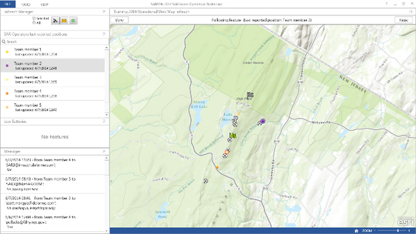
Finally, during the SAR Games activities on Friday, we teamed up with our friends at DeLorme to test the integration of InReach, Collector for ArcGIS, and the Operations Dashboard for real-time tracking and operational mapping. We showed this on live maps in both the Hilton command post and remote command post at High Point State Park. During this time I also hung out with the Alpha SAR Team and discussed the future of GIS in their operations.  


Overall, here is what I learned this year at SARCON2014:

1) The common theme across the Arkansas SAR, ASRC, MRA, and NASAR communities is the concept of remote support for search operations. 
2) Disconnected capabilities are a must - you must be able to support your operation with no internet access for at least 72 hours. However, there are creative ways to leverage support from outside the command post...
3) In general, little work has been done using GIS outside of search operations. I have not spoken with a single team that has incorporated GIS into preventative search and rescue (PSAR) or rescue response (optimal siting of resources, suitability analysis, etc). 

I look forward to giving a more detailed report at the SARGIS6 Meeting in a few weeks!


ps beware of the Alaskan Embassy and anything offered to you in another language.


Friday, May 23, 2014

Search and Rescue GIS 2014 Eastern US Tour


2014 has already been a great year for WiSARGIS. The community has rallied around some common workflows and is always discussing cutting edge technology on the SARGIS Discussion Group. In addition the Mountain Rescue Association is showing leadership in the Community by beginning their first implementation of a geo-enabled mission collection system (more on that soon!).  


On Monday, I leave for Forth Smith Arkansas where the University will be hosting a cadre of MapSAR Instructors. Wes Cleland, Mark Hollingshead, Caroline Rose, and Marcus Kitchens will be teaching MapSAR to a class of GIS Professionals who support agencies throughout the "Tri-State" area (Oklahoma, Arkansas, Missouri). This event is supported by the NAPSG Foundation and Esri. Also members of the GISCorps will be in attendance as well!

Then, on May 31st, the University of Virginia will be hosting the 40th Annual Meeting of the Appalachian Search and Rescue Conference and  Blue Ridge Mountain Group's 40th Anniversary event where I will present on the status and future of the SARGIS Community. This should be a great event in a region I have not spent nearly enough time in. 

After this, FDNY Fire Captain Steve Pollackov and I will present at The National Association For Search And Rescue and the Mountain Rescue Association National Conference (SARCON2014) in Woodcliff, New Jersey. I will be sitting the Command Post during the SAR Games as well, showing how GIS can be used for planning, operations, logistics, command and public information during an incident or training (more to follow!). I have not been back home in a while, it might be time for some real pizza.

This should be a great trip and I will be sure to highlight what I learn here on the blog. Then I will present on this at SARGIS6 in Dunsmuir, CA later in June. I hope to see some of you at these events so we can catch up. 


Special Thanks to Mamata Akella on the NPMap / ArcGIS Online integration!