Showing posts with label GISCorps. Show all posts

Thursday, January 23, 2014

Search and Rescue GISCorps Team Members sworn in as Disaster Service Workers

Today history was made in Sacramento, CA!

Thanks to the hard work of the GISCorps and California Office of Emergency Services, members of the California GISCorps SARGIS pilot program have been sworn in as Disaster Service Workers (pending background and paperwork processing).


This means that the GISCorps members trained in MapSAR and other SARGIS tools can be called up as mutual aid resources by the State to help with missing person searches, recoveries, and any type of disaster where a GIS resource is needed. We will be discussing topics like standard training and qualifications, remote support, and equipment provisioning in future meetings. 

Don't forget the GISCorps can volunteer to help on project work as well, don't wait until there is a disaster! There is probably a member near you and their response area is worldwide.

A very special thank you to Lorri Peltz-Lewis (GISCorps / USFS), Matt Scharper (CalOES), Tom Patterson (Esri, retired), and the California OES GIS Team for making this possible. 

To find out more, see the California Disaster Service Worker Volunteer Program website.

So....which State will be next? How long until all 50 recognize the need for GIS in search and rescue operations? Let us know if you would like to see something similar in your State.

Wednesday, November 20, 2013

Happy #GISDay from Kenya


Team - 

Today is GIS Day around the world and it has been a very busy year. I am here at ICCM 2013 and learning a lot about what everyone is doing in the CrisisMapping community. 

Most recently the Philippine typhoon and MidWest tornadoes have GIS specialists across the globe working in conjunct with the CrisisMapping community to support response agencies. 

Here are some examples of maps being produced for the Philippines response: 


I'd like to recognize the great work of the GISCorps and MapAction this year and look forward to the building bridge we have built between the SAR and GIS professional community.

Monday, November 11, 2013

Tropical Storm #Haiyan / #YolandaPH map resources


View Larger Map of tweets validated through the MicroMapper platform and mapped by GISCorps. For more maps and apps click through the gallery below. 

As Tropical Storm Haiyan / Yolanda makes it way into mainland Asia, the relief efforts are fully underway in the Philippines. I wanted to take a moment here and point out some maps and resources that may be of interest to the Search and Rescue community. 
The CrisisMapping community is serving the United Nations OCHA and UNDAC Teams with up to date information from a wide variety of sources to provide situational awareness and up to date base data for their maps. Check out these sites and the maps below for more information. We will learn a lot from this event and please keep the Search and Rescue and other teams in mind as they are currently engaged in life saving operations.


Here is a partial list of data sources: 


·        Schools and Hospitals (OSM)
·        Maximum Storm Surge (NOAH)
·        Admin Boundaries
·        Cloud cover (NASA, Nov. 9th)
·        Weather Stations (NOAA)
·        Recent earthquake (USGS)
·        OpenStreetMap

Monday, January 7, 2013

GISCorps volunteers assist in a Search & Rescue pilot project in California

GISCorps volunteers assist in a Search & Rescue pilot project in California.

Check out the link. This is excellent news from the GISCorps!

What is happening?

In late 2012, GISCorps received a request for volunteers from a consortium of GIS and Search and Rescue (SAR) professionals from Sierra Madre Search and Rescue Team, Esri, Sequoia and Kings Canyon National Park, Yosemite National Park, Grand Canyon National Park, and Mountaineer Rescue Group who have developed a Search and Rescue application called MapSAR. The consortium requested assistance to fill three GIS Specialist positions to support a pilot project in California using MapSAR. Those three positions were: GIS Trainers, GIS Practitioners and GIS Developers. The detailed job description for each position and other additional information is included in this document.

Who is GISCorps? From their website:

GISCorps started life in October 2003 in Atlanta, Georgia, when the URISA Board unanimously approved it as an initiative of URISA. This happened after an intensive summer of brainstorming, conceptualizing and a lot of hard work required to translate an idea into a well designed proposal. GISCorps is now a URISA program and operates entirely on a volunteer basis. The core committee members, most of whom are themselves GISCorps volunteers, run the program with administrative help from the staff at URISA. They reside in different states accross the United States and Canada and use a wiki site to work collaboratively, mostly at nights and on weekends. The links that follow describe in detail the mission and the operations of the GISCorps.

GISCorps volunteers' services will help to improve the quality of life by:

  • Supporting humanitarian relief.

  • Enhancing environmental analysis.

  • Encouraging/fostering economic development.

  • Supporting community planning and development.

  • Strengthening local capacity by adopting and using information technology.

  • Supporting health and education related activities.


GISCorps has accepted the challenge and the California Emergency Management Agency SAR Operations and the National Park Service are anticipating the integration of GIS Specialists into their ranks for supporting Search Operations with GIS. This is a great opportunity to bring in GIS professionals and their expertise to support an inherently spatial problem: searching for missing persons. Once we have learned from this experience it can be taken to a national / international level.

MapSAR San Bern

Sunday, December 9, 2012

Pre-planning is Half the Battle

Here at the MapSAR Training in San Bernardino there have been a lot of meaningful sidebar conversations. Speaking with a member of Ventura County SAR, I felt like it was time to open a broader discussion on Search Operation pre-planning. We want to know, what types of geographic features you are using on operations?

Here is a list we discussed:
  • Roads
  • Trails
  • Trailheads
  • Streams
  • Powerlines
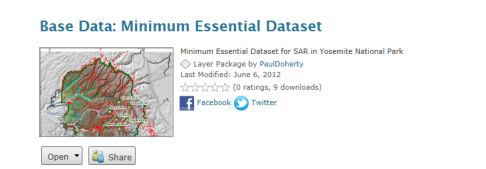
These are just some of the datasets that should be included in your Minimal Essential Dataset (MED) and could be used for planning search segments in advance of an incident.

Image

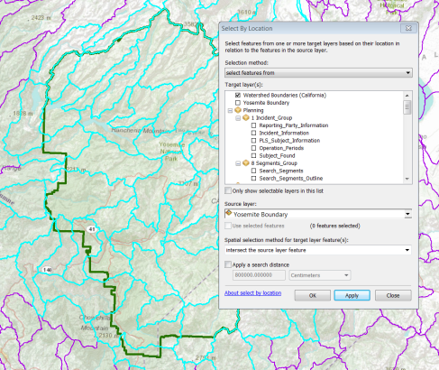
However, over the past year our Using GIS in WiSAR group have been tinkering with the use of Watershed Boundaries for the use of planning areas or even starting points for segment delineation. 

*UPDATE* March 3rd 2017

Why watersheds?  "It is evident that the topography affects how people move through their environment, so instead of looking at how far they travel in a straight line from where they were last seen in order to predict where to look for them, perhaps it would be better to analyze the topographic features around them. One way in which to do this is by analyzing their movement between watersheds." - Read more in Jared Doke's MS Thesis.

This has been further supported in research by Elena Salva in a research article titled: Evaluating Lost Person Behavior Models

Now that the latest National Hydrological Dataset has been released, it would be a good idea to download the dataset and add it to your MED.

Image

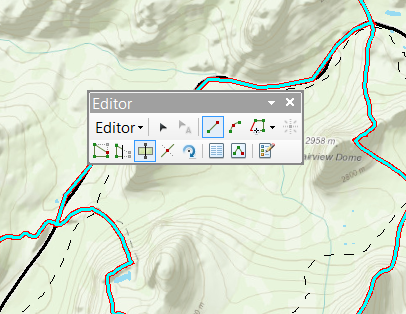
Then you can use some of the editing tools, such as cut polygons to begin breaking down the watershed boundaries into searchable segments by other features such as roads and trails.

EditorCutPoly

This is a big breakthrough for Using GIS in WiSAR and researchers Jared Doke, Robert Koester, Don Ferguson, and Charles Twardy are testing these watershed boundaries against/with Lost Person Behavior models for determining Probability of Area. In addition Lori Peltz-Lewis will be working with GISCorps to make sure SAR Teams in California have this and other datasets for their MED.


I hope this post sparks discussion on pre-planning and discuss what others are doing or will do to prepare for their next search.

For those of you "North of the Border"....Here is a watershed data source that was forwarded to me today for Canada. I have not taken a look yet, but feel free to check out the
link.

http://geobase.ca/geobase/en/data/nhn/description.html

NHN dataset (Nation Hydro Network) that NRCAN provides. It has 1:50k data (interpolated from coarser data where finer data is not available) standardized across Canada. In some regions, the provinces have partnered up to provide better quality data and rely less on the
general computer model to compute the data.

*UPDATE* March 3rd 2017

The USA Watersheds are also available in ArcGIS Online for use in web maps, apps, and ArcGIS Pro through the Living Atlas of the World program. You can test this in the web mapping app embedded below.