Monday, August 11, 2014

2014 SAR Special Interest Group Meeting


This is just a quick recap of items discussed at our Search and Rescue Special Interest Group Meeting at the 2014 Esri International User Conference in July. 


  • An update on MapSAR / GISCorps pilot project. There was a lot of interest and it sounds like it is time to expand beyond California!
  • An update from Caroline Rose on her MS Project. She is looking to interview more SAR personnel on the types of mapping solutions they currently use so we can design better solutions in the future (ie "MapSAR 3.0"). 
  • Karyn Tareen spoke about  opportunities to collaborate and learn from other workflows eg USAR, Damage Assessment. She and her GeoCove team have already pioneered some  new workflows.
  • Robert Koester has secured funding to continue building out the ISRID Database
  • D4H has added support for the International Search and Rescue Incident Database and MapSAR!
  • A brief update on SARGIS6 East and West. There were a lot of similar themes discussed and everyone seemed very happy with the collaboration between the two locations. 
If you were there or have questions - please feel free to add comments!

Here is a map of attendees.


View larger map


Wednesday, July 2, 2014

USGS Historical Topographic Map Explorer for Search and Rescue

While we always want to use the most up to date maps (a Local GIS-produced basemap, World Topographic, Open Street Map)  for our missing person search operations - there are times when historic maps are necessary for our investigation. For instance what if your missing person was believed to be carrying a historic map - you might want to interpret the landscape through the same map they were using. 

This dynamic map allows you to view and download historic quad maps based on location - this could be a very useful tool for Search and Rescue in the US! 

Check it out: USGS Historical Topographic Map Explorer

1) Type in a place and click on the map
2) Click timeline maps to view in main window

3) Slide transparency on map to compare, or drag/drop to re-order maps


The downloads appear to be available as geo-pdfs only - but these may be converted to more GIS friendly formats (.tif). I look forward to hearing if any teams have used this resource and any feedback they may have. 

If you simply want a seamless USGS Topo - this is already a layer in ArcGIS Online that can be used as a basemap in ArcGIS Desktop or ArcGIS Online while connected to the internet.


View Larger Map

If you are looking for the USGS topographic maps to run locally in ArcMap - most states have a download page for pulling the digital raster graphics (DRGs). I have also heard that Matt Jacobs from CalTopo can show how to use the seamless tiles he has produced inside your GIS. 

However - basemaps should always be suspect to currency and  used in conjunction with your local minimum essential dataset (read Chapter 3).

Thanks USGS for making data open and easier to find!

Monday, June 23, 2014

#SARGIS6 Discussion and Report

This blog post highlights the activities and topics covered in the 6th Annual Search and Rescue GIS Meeting. The meeting was held simultaneously in Dunsmuir, California and Morgantown, West Virginia. The final agenda can be found here: https://esri.box.com/SARGIS6Agenda


MapSAR Training - Thursday and Friday


We kicked off the week on Thursday morning at the Dunsmuir High School with the Yosemite ("Clark SAR") Tutorial. There were both GIS Professionals and SAR Professionals (most with little or no GIS experience) in the room. The students were able to complete the tutorial in one day and get through the basics of MapSAR. Excellent instruction was provided by Jared Doke, Caroline Rose, Rick Laing, and Dave Hansen from the GISCorps. On Friday we then started from scratch and launched MapSAR to respond to a fictional scenario on Mount Shasta, the "Hunter SAR". 

Friday Evening


After some free time to check out the town of Dunsmuir and an open house at FireWhat Headquarters we went to the theater for a keynote address on WiSAR GIS Research and an introduction to the FireWhat Team. This was followed by some live music, dessert, and a raffle on top of the Dunsmuir Hotel rooftop. 

Saturday

Beautiful Mount Shasta was a great backdrop for our meeting.


For the rest of the conference we spent time up at the Mount Shasta Ski Park after a great interpretive talk from Nick Meyers, Mount Shasta Ranger. On Saturday Morning we received a MapSAR update from Jon Pedder and were introduced to the Antris Registry by Kaila Beattie. Then we heard some excellent lightning talks:
  • Who are the GISCorps? Dave Hansen
  • Using GIS for Kansas USAR Jared Doke
  • Why don’t we all just use GIS? Caroline Rose 
  • Remote Support for WiSAR Don Ferguson
  • Using cell phone analysis for WiSAR George Durkee
In the afternoon - we used our "Hunter SAR" scenario to try out some new technology in conjunction with MapSAR. We published our incident data to an ArcGIS Online web map and launched the Collector for ArcGIS for mobile data collection. We also used DeLorme inReach devices for situational awareness in the field - we always knew the location of our teams. 


Finally - we tied all of this information together using the Operations Dashboard to track team status and instantly view photos of clues from the field. This is the first time we have tried this integration and it worked quite well. We still used the paper maps from MapSAR as a fail-safe method to make sure teams had the information they needed in the field. 

For free training on this new technology:
Finally, we finished off the meetings with presentations:
Both days of the meeting were shared via webcast with SARGIS East. Despite technical difficulties most of the presentations were recorded and available (I am working on converting these videos into a viewable format right now).


What did we learn? What's next?


  1. It is time to present what the SARGIS community has to offer to agencies that have jurisdiction, not just the volunteers
  2. We need to simplify deployment of MapSAR / IGT4SAR workflows for Day I of operations
  3. We need to move MapSAR / IGT4SAR to one code-sharing framework (GitHub)
  4. How do we implement remote support procedures?
  5. Should the WiSAR GIS group become a non-profit (5013c) organization?
  6. UAV/S have a role in WiSAR - but it is yet to be determined how they can be used effectively, we need to do more research


We are looking forward to SARGIS7 and potential locations have already been discussed (Simon Fraser University, University of Wisconsin - Madison, Estes Park, Dunsmuir, CA).

Look for updates from SARGIS East soon as well.

Please continue the discussion or ask followup questions from the presenters on the SARGIS Discussion Group.

Sunday, June 8, 2014

Search and Rescue GIS at #SARCON2014


The last stop of my Eastern US tour brought me to New Jersey for the MRA / NASAR 2014 Search and Rescue Conference. New Jersey Search and Rescue are pioneers in search operation mapping and communication - so this was the perfect place to talk about the importance of GIS in wildland search and rescue. The conference was very well run and a great time to connect with friends and learn more about what others are doing.

Don Ferguson gave an excellent talk about minimum essential data for situational awareness and spatial analysis during search operations. He also showed the power of spatial analysis, such as travel cost modeling for increasing your theoretical probability of area


Captain Pollackov from FDNY GIS provided a detailed account of how GIS was used for Hurricane Sandy and the Super Bowl, as well as a sneak preview of how FDNY will be using GIS in the future. Our friends at ICE-SAR were very impressed. 


Jon, Jennifer, Jason, Don, Cole and myself were extremely busy at the Esri booth providing mini training sessions to old friends, but also many MRA and NASAR Teams that have not begun implementing GIS into their operations. I also presented and discussed the MRA Mission data collection system using ArcGIS Online. Here is a link to the training videos if you have not seen them already. 


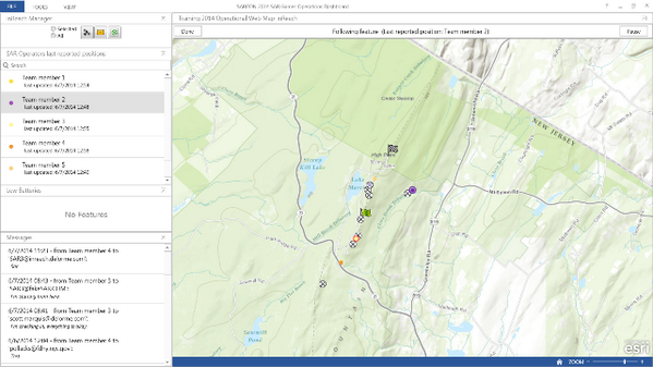
Finally, during the SAR Games activities on Friday, we teamed up with our friends at DeLorme to test the integration of InReach, Collector for ArcGIS, and the Operations Dashboard for real-time tracking and operational mapping. We showed this on live maps in both the Hilton command post and remote command post at High Point State Park. During this time I also hung out with the Alpha SAR Team and discussed the future of GIS in their operations.  


Overall, here is what I learned this year at SARCON2014:

1) The common theme across the Arkansas SAR, ASRC, MRA, and NASAR communities is the concept of remote support for search operations. 
2) Disconnected capabilities are a must - you must be able to support your operation with no internet access for at least 72 hours. However, there are creative ways to leverage support from outside the command post...
3) In general, little work has been done using GIS outside of search operations. I have not spoken with a single team that has incorporated GIS into preventative search and rescue (PSAR) or rescue response (optimal siting of resources, suitability analysis, etc). 

I look forward to giving a more detailed report at the SARGIS6 Meeting in a few weeks!


ps beware of the Alaskan Embassy and anything offered to you in another language.


Saturday, May 31, 2014

GIS Discussions at the Appalachian Search and Rescue Conference 40th Anniversary

Beautiful UVA Campus!
"In commemoration of our 40th anniversary and the overwhelming dedication and commitment given by the conference for the past 40 years, we are hosting a celebration."

Don Ferguson and Eric Menendez leading a roundtable discussion on remote collaboration for Search Operations and Geographic Information Systems. Don has already experimented using ArcGIS Online and Wikispaces to assist in extended searches. 
Here at the University of Virginia in Charlottesville, VA there have been some very productive discussions about incorporating GIS into SAR. More than just discussion here are some immediate actions items:

Define protocols for remote collaboration in the Region


Design a catalog of information products that can be requested by search managers ("It should be as simple to follow as a Chinese Food Menu") 


Agree on some basic standards of what is required to generate these information products

  • Assignment maps
  • Briefing maps
  • Minimum Essential Dataset packages
  • Analysis (e.g. Terrain models, Cell phone analysis, Spatially-enabled probabilities (POA / POD)) 

Construction of a region-wide trail network database


More discussions about emerging technology and how they fit in (Cell Phone Analysis, UAVs, etc).

The slides from my plenary talk are available for download from here.

This is the first time I have seen a volunteer community come together to discuss remote collaboration and incorporation into GIS as a platform. It is very impressive and I am hoping the GISCorps members in the region can step in to help.

Other great talking points include: 
  • Veterans can be extremely valuable in austere disaster response environments, especially if supported with GIS - Lourdes Tiglao, Team Rubicon
  • Search Theory will evolve with the use of GIS - Dr. Charles Twardy and Robert Koester
  • Stop referring to it as "Lost Person" incidents, rephrase as "missing person" incidents. This will help engage the Law Enforcement Community and see the SAR functions as a great asset. - A State SAR Coordinator
All in all, this is a great organization and I am very happy they invited me out to meet with them and share what the SARGIS community is working on. Thank you ASRC and BRMG for inviting me to this event!

Wednesday, May 28, 2014

MapSAR Training - Ft. Smith, AR

This training event was a success! GIS and Public Safety professionals from three adjacent states (MO, OK, AR) learned how to use GIS for Search and Rescue - but more importantly they were all in the same room together meeting face to face.

After dealing with some serious weather related obstacles during my trip (diverted to College Station and spending the night in Houston), I finally made it to Fort Smith. Luckily Mark, Marcus, and Caroline were ready to present the tutorial and get started without me.


On Day 1 we covered the Yosemite Search tutorial and helped everyone get familiar with the MapSAR interface. Once students had their initial setup configured they were off and running - making their first maps. Who knew unzipping folders could be so much fun?


On Day 2 - Wes Cleland presented a local fictional search scenario that would involve a multi-agency response and the students had to respond with MapSAR on their own. This reinforced what was taught on Day 1. We also covered the overall topic of using GIS for SAR with local media in attendance which was a great opportunity to do some outreach. 

Finally, in the afternoon Wes reviewed a recent missing aircraft / pilot search with a very personal and thoughtful tone. He explained some of the challenges they faced and what was learned during this process. ArcGIS online was used during this operation to collaborate / coordinate planning and operations - but not until the search was well underway.


This led to a great discussion about how to better prepare for search operations. All in attendance agreed a follow up meeting is needed to outline the core workflows (define search boundary, segment the map, make common maps available to general and command staff) and information products required for search operations. It is also important to draw commonalities with disaster response, such as the recent tornado in nearby Mayflower / Vilonia, Arkansas. For me, getting to see this in person was very compelling.


Key lessons learned:

1) Have incident templates and minimum essential datasets ready to go before the incident. This seems obvious but experiencing the time wasted in the process made this very clear.

2) We need to create a visual information product "menu" that non-GIS responders can choose from early on in search operations then order the resources needed to create them (investigators, experts, GIS staff). This will help prevent information overload or misuse of resources.

3) There is a great deal of potential for using cellular phone / tower for search operations - but a synthesis of how to use this information is not (yet) available to the community. 

I am sure those of you in attendance have your own thoughts and I'd love to hear them in the comments below.

Thank you to the students and their agencies, the Esri Disaster Respinse Program, the Esri St. Louis Refional Office, the University of Arkansas, the GISCorps, and the National Alliance for Public Safety GIS for making this possible. 


Friday, May 23, 2014

Search and Rescue GIS 2014 Eastern US Tour


2014 has already been a great year for WiSARGIS. The community has rallied around some common workflows and is always discussing cutting edge technology on the SARGIS Discussion Group. In addition the Mountain Rescue Association is showing leadership in the Community by beginning their first implementation of a geo-enabled mission collection system (more on that soon!).  


On Monday, I leave for Forth Smith Arkansas where the University will be hosting a cadre of MapSAR Instructors. Wes Cleland, Mark Hollingshead, Caroline Rose, and Marcus Kitchens will be teaching MapSAR to a class of GIS Professionals who support agencies throughout the "Tri-State" area (Oklahoma, Arkansas, Missouri). This event is supported by the NAPSG Foundation and Esri. Also members of the GISCorps will be in attendance as well!

Then, on May 31st, the University of Virginia will be hosting the 40th Annual Meeting of the Appalachian Search and Rescue Conference and  Blue Ridge Mountain Group's 40th Anniversary event where I will present on the status and future of the SARGIS Community. This should be a great event in a region I have not spent nearly enough time in. 

After this, FDNY Fire Captain Steve Pollackov and I will present at The National Association For Search And Rescue and the Mountain Rescue Association National Conference (SARCON2014) in Woodcliff, New Jersey. I will be sitting the Command Post during the SAR Games as well, showing how GIS can be used for planning, operations, logistics, command and public information during an incident or training (more to follow!). I have not been back home in a while, it might be time for some real pizza.

This should be a great trip and I will be sure to highlight what I learn here on the blog. Then I will present on this at SARGIS6 in Dunsmuir, CA later in June. I hope to see some of you at these events so we can catch up. 


Special Thanks to Mamata Akella on the NPMap / ArcGIS Online integration!